Cultural Mapping & Geological Significance
A 500-million-year-old landscape with deep cultural history.
Independent geological analysis has identified several important landscape features across the Dookie Hills and broader Goulburn Valley region that are closely linked to Aboriginal cultural heritage.
One of the key geological formations in this area is Cambrian-aged greenstone, which has historically been an important source of material used by Aboriginal people for stone tool production. Archaeological records show that many sites in the local area contain evidence of tools made from this material, highlighting the long-standing cultural significance of these geological formations.
In addition to the greenstone outcrops, prior stream systems and historic watercourses across the landscape are also considered culturally sensitive areas. These landforms were historically important places for travel, resources, and cultural activity, and often contain archaeological and cultural heritage values.
Importantly, many of these features are not currently shown on the State’s Aboriginal Cultural Heritage Sensitivity Maps. This is largely due to the scale of the mapping used when those maps were produced (1:250,000), which is too broad to accurately identify smaller but culturally significant geological features such as the greenstone outcrops and historic stream channels present in this region.
The geological mapping undertaken for this project also highlights the presence of sensitive wetland systems and geological features within the Central North Renewable Energy Zone area that may not have been fully considered in current planning assessments.
This work demonstrates that the Dookie Hills and surrounding landscape contain complex geological and cultural layers that require careful, detailed assessment to ensure cultural heritage is properly understood and protected.
Protect Dookie & the Goulburn Valley supports responsible renewable energy development, but this work highlights the importance of thorough, on-the-ground assessment of cultural and geological landscapes before major infrastructure is planned. Our goal is simply to ensure that the full cultural, environmental and geological story of this region is properly understood and considered.
Summary - Why this landscape matters:
The Dookie Hills contain Cambrian-aged greenstone, historically used by Aboriginal people to make stone tools.
Prior stream channels and historic watercourses across the landscape are culturally sensitive areas and often linked to Aboriginal activity and travel routes.
Many of these features do not appear on current State Aboriginal Cultural Heritage Sensitivity Maps because the original mapping was created at a broad scale (1:250,000), which cannot capture smaller but significant geological features.
Recent geological analysis shows additional wetlands, streams and geological formations within the Central North Renewable Energy Zone that may not have been fully considered in current planning assessments.
A culturally significant landscape hidden beneath broad-scale maps.
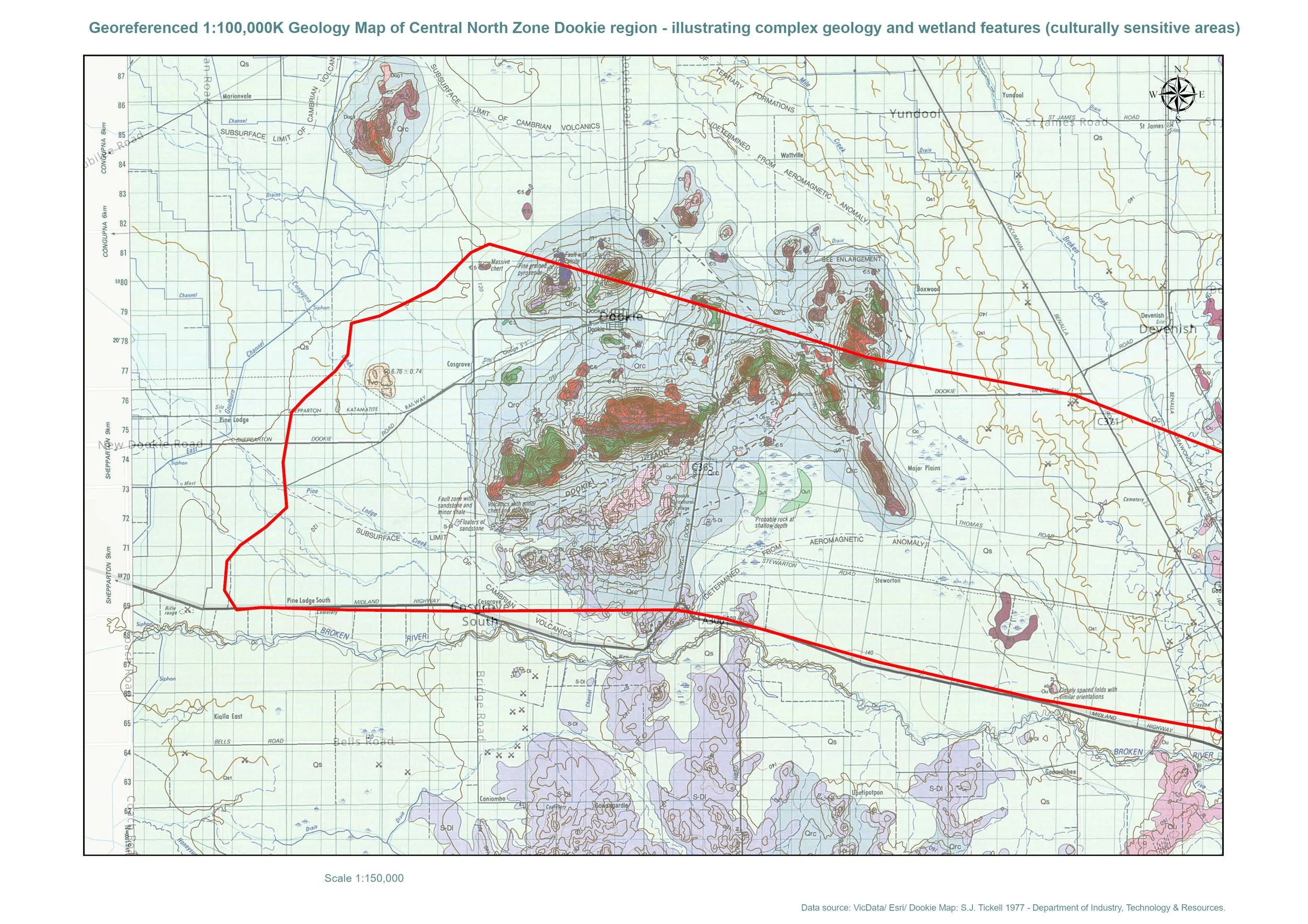
Red boundary: Central North Renewable Energy Zone
Highlighted geological formations: Cambrian greenstone outcrops associated with Aboriginal stone tool production
Blue line systems: Historic and prior stream channels and wetlands
Geological Map of the Dookie Region
This geological map of the Dookie region highlights the complex volcanic and greenstone geology that forms the Dookie Hills landscape. The coloured formations represent different geological units, many of which date back to the Cambrian period (over 500 million years ago).
These ancient greenstone formations have long been recognised as important sources of stone used by Aboriginal people for tool making, with archaeological sites recorded throughout the region.
The map also shows the surrounding stream systems, wetlands and landscape features that historically supported Aboriginal movement, resources and cultural activity.
The red boundary overlay highlights the Central North Renewable Energy Zone, demonstrating that many of these geological and hydrological features occur within or close to the proposed development area.
Because official cultural heritage sensitivity maps were created using broad-scale mapping, many smaller geological formations and historic stream systems visible here are not captured in current State mapping, despite their known cultural and environmental significance.
This reinforces the need for detailed local assessment and careful consideration of the landscape before major infrastructure development occurs.