Protecting the Goulburn Valley Food Bowl, Cultural Landscapes & Community Future
Renewable energy must be delivered in the right place. Strengthening, not displacing, food and energy systems.
Climate action and protection of agricultural land, culture and community must go hand in hand.
Why we’re concerned
The proposed Central North REZ overlaps land producing some of the highest dryland wheat and canola yields in Victoria, contributing up to 15% of the state’s GrainCorp canola intake and forming part of a nationally significant low-emissions supply chain.
Despite this, the current planning process relies on incomplete cultural heritage mapping, lacks comprehensive floodplain and visual impact assessment, and fails to account for this region’s tourism and cultural significance.
The absence of mapped cultural heritage sites reflects a lack of survey, not a lack of cultural values and no region-wide assessment has been undertaken to address cumulative impacts on agriculture, biodiversity, hydrology, or landscape character.
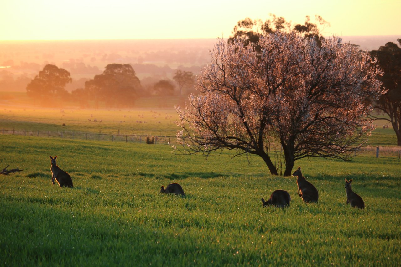
We strongly support renewable energy and Victoria’s transition to a low-carbon future. However, we are deeply concerned that the proposed Central North Renewable Energy Zone (REZ) has been mapped across one of Victoria’s most valuable and sensitive landscapes — the Dookie district and the heart of the Goulburn Valley Food Bowl.
Our concerns are not ideological. They are evidence-based, community-driven, and supported by independent, agricultural analysis and council data.
-
Dookie forms part of the Goulburn Valley, widely known as the Food Bowl of Victoria for its extraordinary agricultural productivity.
The region contributes significantly to the state’s:
fruit and orchard produce (peaches, pears, apples, stone fruit)
dairy production and processing
vegetable supply
grain and oilseed production
national and export food processing (SPC, Bega, Freedom Foods, Unilever)
food manufacturing and logistics industries
The Greater Shepparton region directly underpins Victoria’s food security and supplies major supermarket chains, processors, and export markets.
Dookie’s role in the food bowl
Dookie is the dryland cropping engine of the Goulburn Valley. It produces some of the states largest volumes for:
wheat
canola
barley
pulses
rotational cropping that supports dairy & feed supply
Key facts:
Wheat yields average 5–8 t/ha
Canola yields average 3–4 t/ha
Dookie contributes 15% of GrainCorp’s total Victorian canola intake
Up to 20% of canola processed at the Numurkah crush plant comes from the Dookie district
Three local farms have also been selected for GrainCorp NEXT, a national low-emissions canola supply chain program involving only 12 farms Australia-wide. This underscores the region’s importance not just to food security, but to emissions-reduction initiatives and biofuel production.
Once strategic agricultural land is fragmented or compromised by permanent infrastructure, it cannot be replaced.
Protecting Dookie means protecting the future food security of Victoria.
-
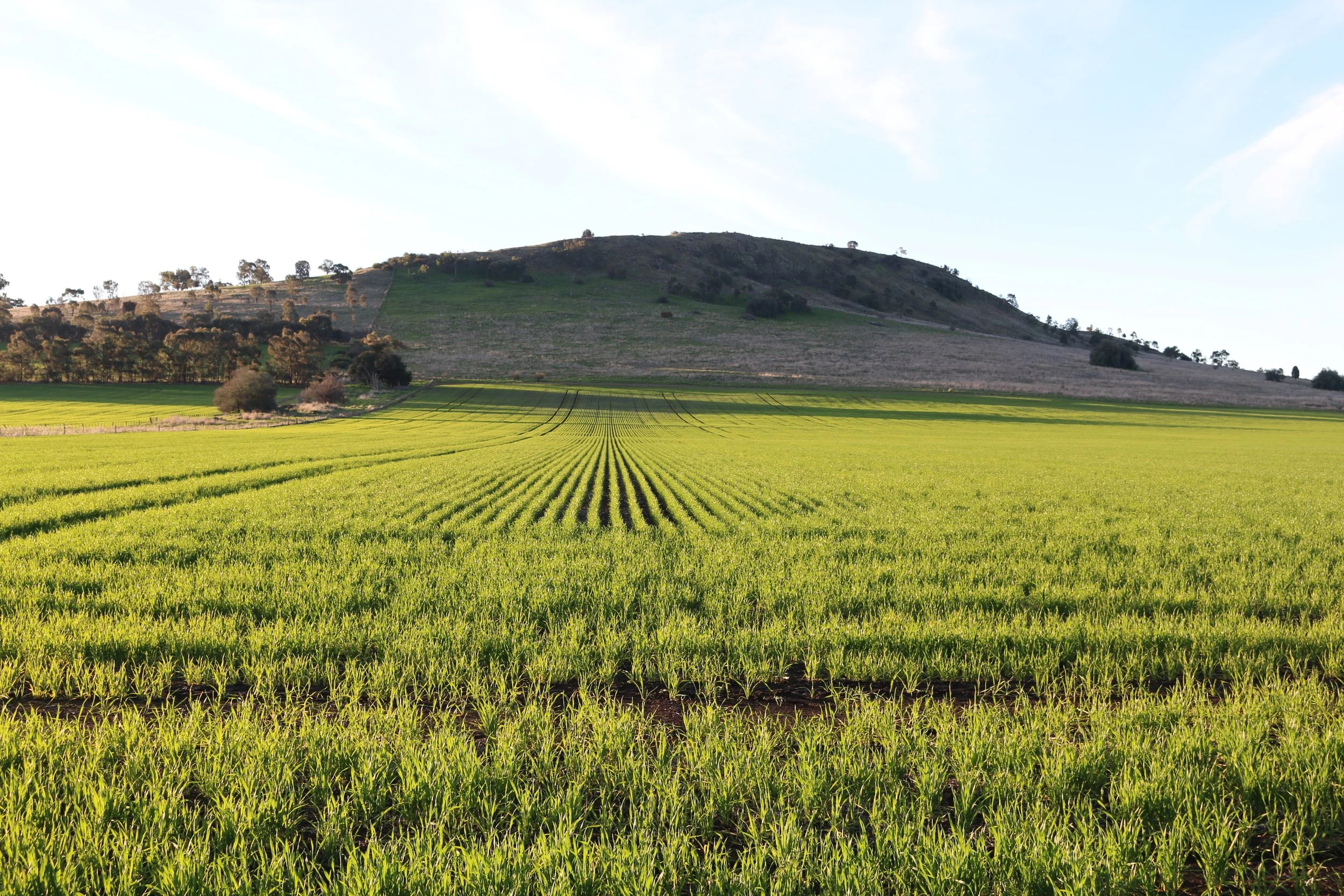
The Dookie district is not marginal farmland. It is high-performing, strategic agricultural land that plays a critical role in Victoria’s food and biofuel supply chains.
Dookie’s soils including the Shepparton Formation and basalt-derived loams are classified as high-capability agricultural land.
This land:
produces consistent, high-performing yields
withstands climate variability better than many regions
supports critical food, feed and biofuel supply chains
contains decades of farming investment and infrastructure
The REZ would fragment or remove land that cannot be relocated or replicated.
Victoria has committed to protecting Strategic Agricultural Land — this proposal contradicts that commitment.
-
The region contains significant Aboriginal cultural features, including:
greenstone and chert outcrops
quarry sites
artefact scatters
ancient stream beds and drainage lines
undisturbed hill and plain surfaces likely containing unrecorded sites
Current planning relies heavily on Aboriginal Cultural Heritage Sensitivity mapping that is based on coarse, statewide geological datasets. These datasets do not capture many of the known cultural features present in the Dookie landscape.
Importantly:
The absence of mapped sites does not mean an absence of cultural heritage
The region has not undergone comprehensive on-ground cultural heritage surveys
Unlike heavily modified irrigation districts, much of the Dookie landscape remains relatively intact, increasing the likelihood of unrecorded cultural sites
Planning decisions are therefore being made using incomplete information, placing cultural heritage at unacceptable risk.
The unique geology of the region is of high cultural heritage landscape scale significance.
The REZ threatens these values.
-
The proposed REZ footprint overlaps:
Brolga habitat
wetlands and natural drainage lines
remnant native vegetation
broad floodplain systems across the Dookie plains
Since the decommissioning of historic stock and domestic channels, water now moves more naturally across the landscape. This has altered flood behaviour and increased reliance on natural floodways.
Despite this:
No region-wide floodplain or cumulative hydrology assessment has been undertaken
The potential for infrastructure to block, redirect or intensify flood flows has not been properly assessed
Downstream impacts on farmland, ecosystems and wetlands remain unclear
Large-scale infrastructure in flood-prone agricultural landscapes carries long-term risks that must be properly understood before decisions are made.
-
Dookie is a growing tourism destination and a place of exceptional landscape value.
The region supports:
Mount Major Summit Walk — the only “mount” walk in the Goulburn Valley
Dookie Rail Trail
seasonal canola tourism
Silo art trail
cycling events
weddings, retreats and regional hospitality businesses reliant on scenic views
Mount Major provides panoramic views across the surrounding plains — yet no comprehensive visual impact assessment has been undertaken from:
the Mount Major summit
walking trails
tourism corridors
key viewing points across the district
Industrial-scale energy infrastructure would be visible for kilometres and would permanently alter the character of this landscape.
Key Visitor Assets
Dookie Rail Trail — A signature attraction offering two routes (9.6 km and 6.4 km return) through rolling agricultural land, vineyards, olive groves, and native bushland. Interpretive signage explains Dookie’s agricultural and cultural heritage, while seating and viewing points create a welcoming experience for families and casual cyclists. Stage 2 (2020) provides a broader view across the valley between Mount Major and Mount Saddleback, with ongoing plans to extend the trail to Shepparton, strengthening regional connectivity
Mount Major Circuit — A 5 km return walking trail offering panoramic views of the Dookie Hills and Goulburn Valley; the only mount walk in the region, making it a unique destination for hikers and photographers
Mulana Nin Iyoga (“Spirit of Stone”) Walking Trail — A 4.6 km cultural and interpretive trail on the Dookie side of Mount Major, providing insight into natural and cultural values of the area with interpretive signage and 360-degree summit views
Nomadic Silo Art and Flowering Gum — Iconic local landmarks combining creativity and nature. The silo art and 125-year-old gum tree are celebrated photographic subjects and reflect Dookie’s identity as a creative rural community
Spring Canola Bloom — major seasonal tourism draw
Professional Photography Hot Spot - Dookie’s panoramic landscapes and rural authenticity make it a favourite backdrop for local photographers and their clients for family, maternity and wedding photography.
Tourism provides a growing source of local income, benefiting:
accommodation
hospitality
event venues
retail
cycling groups
Industrial-scale energy infrastructure in view of these landscapes would cause:
loss of scenic amenity
reduced visitor numbers
harm to local businesses
a permanent change to the cultural and visual identity of the region
-
The GSCC community survey revealed:
84% of residents had no opportunity to participate in consultation
66% felt “not informed”
74% oppose the REZ
76% said the boundary selection process was flawed
Not a single respondent described the consultation as:
transparent
timely
inclusive
This represents a fundamental failure of process. Community concern is not isolated or anecdotal.
These results point to a process that has failed to meaningfully engage with affected landholders, Traditional Owners, businesses and residents.
Good planning requires transparency, accurate data and genuine community participation — all of which have been lacking.
-
The community is not anti-renewable energy.
We support:
solar and wind energy
responsible development
emissions reduction
climate action
But these must not come at the cost of food security, cultural heritage, biodiversity, or community wellbeing.
Dookie is simply the wrong place for the REZ.
Wind Resource and Infrastructure Suitability
An independent RMIT University wind study conducted over a 12-month period found the Dookie district to be unsuitable for large-scale wind energy generation, due to consistently low and inconsistent average wind speeds across the Mount Major and surrounding plains.
This technical assessment highlights that the region’s climatic and topographic characteristics are not aligned with high-efficiency wind energy zones. Despite this, the findings of that study have not been referenced or incorporated in VicGrid’s current REZ planning or constraint mapping.
We request that VicGrid obtain and review the RMIT wind-resource data before any further zoning or infrastructure designation is made, to ensure that site selection is evidence-based and consistent with the State’s renewable energy performance criteria.
What the community is calling for
We support renewable energy and climate action.
We believe renewable energy must be delivered in a way that strengthens food systems, energy transition goals and regional communities — not undermines them.
Our ask is simple, reasonable and evidence-based.
-
We are calling for a pause on the current Central North REZ boundary to allow:
proper assessment of agricultural value
recognition of existing food and bioenergy production systems
accurate cultural heritage mapping
full environmental and floodplain analysis
-
Renewable energy infrastructure should not be placed on land that:
consistently produces high-yield crops
supports food manufacturing and livestock systems
supplies edible oils and renewable biofuel feedstocks
underpins emissions-reduction initiatives already in operation
This land is already part of Victoria’s energy transition.
-
We are calling for:
comprehensive on-ground cultural heritage surveys
updated mapping that reflects local geology and landscape features
meaningful engagement with Traditional Owners
recognition that unmapped does not mean insignificant
-
Before decisions are made, we are asking for:
region-wide floodplain and hydrology assessments
evaluation of impacts on wetlands and Brolga habitat
consideration of climate variability and future flood risk
assessment of cumulative impacts across the REZ footprint
-
We are asking for:
visual impact assessments from Mount Major and key viewpoints
consideration of impacts on the Rail Trail, tourism routes and visitor experience
recognition of tourism and recreation as legitimate regional industries
-
We are calling for:
genuine engagement with affected landholders and residents
transparent sharing of data and assumptions
sufficient time for communities to respond
recognition of local knowledge alongside technical expertise
-
The community is not anti-renewable energy.
We support:
solar and wind energy
responsible development
emissions reduction
climate action
But these must not come at the cost of food security, cultural heritage, biodiversity, or community wellbeing.
Dookie is simply the wrong place for the REZ.
Wind Resource and Infrastructure Suitability
An independent RMIT University wind study conducted over a 12-month period found the Dookie district to be unsuitable for large-scale wind energy generation, due to consistently low and inconsistent average wind speeds across the Mount Major and surrounding plains.
This technical assessment highlights that the region’s climatic and topographic characteristics are not aligned with high-efficiency wind energy zones. Despite this, the findings of that study have not been referenced or incorporated in VicGrid’s current REZ planning or constraint mapping.
We request that VicGrid obtain and review the RMIT wind-resource data before any further zoning or infrastructure designation is made, to ensure that site selection is evidence-based and consistent with the State’s renewable energy performance criteria.
-
We believe Renewable Energy Zones should prioritise:
lower-value agricultural land
already-modified or industrial landscapes
areas with minimal cultural and environmental sensitivity
This approach allows Victoria to meet climate targets without sacrificing food security, bio-fuel supply chains, cultural heritage or environmental values.
Our Position
Renewable energy must be delivered in the right place. Strengthening, not displacing, food and energy systems.
Climate action and protection of agricultural land, culture and community must go hand in hand.
How you can support this ask
Sign the community petition
Share accurate information
Engage respectfully in the planning process
Advocate for responsible renewable energy planning